
AirLink MP70
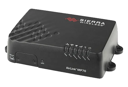
AirLink MP70
The AirLink® MP70 is a high performance, LTE-Advanced Pro vehicle router developed specifically for mission critical applications in public safety, transit and field services.
Offering high power, long range Gigabit Wi-Fi and Gigabit Ethernet, and fast cellular downlink and uplink over LTE-Advanced Pro, the AirLink MP70 unites the fleet with the enterprise network and enables multiple field applications to work simultaneously, further and faster from the vehicle than ever before. LTE-Advanced Pro supports fast 600 Mbps downlink and 150 Mbps uplink speeds making the MP70 ideal for bandwidth intensive applications like HD real-time video streaming, and passenger Wi-fi. The MP70 is also FirstNet Ready™ with support for 700MHz Band 14, and support for priority and pre-emption for first responders.
The MP70 supports advanced remote visibility and instant insight into the vehicle area network (VAN), field applications and assets, and the mobile workforce. Purpose built for the vehicle, the MP70 delivers superior reliability and uninterrupted operation in harsh mobile environments.
HIGH PERFORMANCE VEHICLE AREA NETWORK (VAN)
With dual-band Gigabit Wi-Fi and Gigabit Ethernet, the AirLink MP70 enables a complete portfolio of broadband mission critical applications to work simultaneously, further and faster from the vehicle than ever before. Built for first responders and field personnel, the MP70 offers up to 600 Mbps downlink and 150 Mbps uplink speeds over LTE-Advanced Pro and up to 1.3 Gbps over 802.11ac Wi-Fi (with 3x3 MIMO) and Gigabit 4-port Ethernet. The AirLink MP70 can host up to 128 simultaneous Wi-Fi clients and has multiple SSIDs to support public and private network connections, in addition to managed Wi-Fi services for content filtering. It concurrently connects many mission critical applications in and around the vehicle, including laptops, DVRs and tablets, in addition to providing live video streaming, and rapid and secure access to remote databases, such as record management systems.
The AirLink MP70 supports 26 LTE frequency bands, enabling superior coverage on LTE networks worldwide including dedicated regional Public Safety bands including Band 14. The MP70 has four product variants: An LTE-Advanced Pro variant for North America with support for Band14, a Global LTE-Advanced Pro variant with support for Band20 and Band28; an LTE-Advanced variant for North America and EMEA and one for APAC.
AirLink MP70 supports automatic configuration of the radio based on the SIM (Network Operator) and offers dual-SIM functionality to enable automatic failover between SIMs, providing superior connectivity and cost optimization when roaming.
CONNECTED VEHICLE AWARENESS
The AirLink MP70 increases efficiency, streamlines operations and reduces costs by supporting advanced remote visibility and instant insight into the vehicle area network (VAN), field applications and assets, and the workforce.
Offering built-in vehicle-ready I/O, with the capacity to support AirLink Vehicle Telemetry, the MP70 enables remote monitoring of auxiliary devices such as light bars, sirens and gun racks, and can collect OBD-II and J1939 vehicle telemetry data for engine diagnostics and performance data to monitor vehicle health.
The MP70 offers an integrated mobile events engine to monitor hundreds of router, network, and connected vehicle parameters in real time, and create custom alerts, event triggers and reports. Reports and alerts are synchronized with third party server platforms or AirLink network management software to enable centralized and remote management of critical events.
Utilizing next generation GNSS location technology that supports 48 satellites from 4 different satellite constellations (GPS, GLONASS, Galileo, Beidou), the MP70 provides fast, reliable and precise vehicle location, even in the most challenging environments. The MP70 contains an Inertial Navigation System that allows it to track without satellites, using dead reckoning algorithms integrated with the GNSS. The Inertial Navigation System continues to provide positioning information when the GNSS is unable to acquire satellites. This enables tracking through urban canyons, tunnels and underground parking.
Location information can be streamed from the GNSS locally over the serial port to connected in-vehicle driver navigation and dispatch systems, and remotely over NMEA, TAIP, RAP and XORA protocols for integration with 3rd party applications.
Data Sheets


© Day Wireless Systems.
Motorola Two Way Radio Dealer Oregon, Washington, California, Idaho, Wyoming, Utah, Netherlands, Ireland
DWS Contractors License: OR: CCB # 64950; CA: CSLB # 984020; WA: L&I # DAYWIS*934K1; MT: CR # 162474; ID: RCE # 45759
MOTOROLA, MOTO, MOTOROLA SOLUTIONS and the Stylized M Logo are trademarks or registered trademarks of Motorola Trademark Holdings, LLC
and are used under license. All other trademarks are the property of their respective owners. © Motorola Solutions, Inc. All rights reserved.
Privacy Policy | Terms of Service | Disclaimer | Cookie Policy